
|
Want to find out where to buy?
Click BUYING button above. |
||
|
|
|||
|
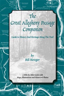
A Mile-by-mile guide with maps, illustrations, and historical photos.
The most comprehensive guide to the rail-trail on the market. |
|||
|
Includes 100 photos, maps, illustrations and survey tables. |
|||||||||
|
A carefully researched history of one of America’s great multi-use trails by an animated storyteller. Even those familiar with the Great Allegheny Passage will find themselves saying: ‘Hey, I didn't know that. . . . a detailed, mile-by-mile guidebook to the Allegheny Passage Trail. Especially written for bikers, hikers, rail buffs, armchair travelers and the non-specialist general reader interested in learning more about the colorful past of the great state of Pennsylvania, The Great Allegheny Passage Companion is replete with extensive historical anecdotes for every leg of the journey distinguishing this especial guide. Nicely enhanced with a profusion of black-and-white photographs, maps, and solid travel advice, The Great Allegheny Passage Companion is an invaluable travel planning resource and reference for anyone seeking to fully experience what the Allegheny Passage has to offer the contemporary traveler. Readers and visitors will find Bill Metzger’s book informative, amusing, and filled with his wonderfully detailed maps, observations, local history, and lore. |
|||||||||
 |
|||||||||
|
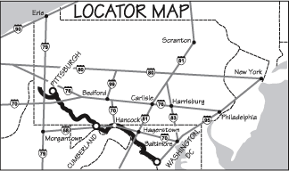
* Map by
the author. |
|||||||||
|
ISBN 0-9711835-2-X,
|
|||||||||
 |
|||||||||
|
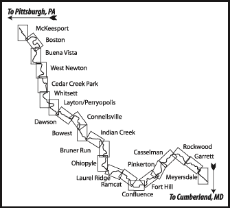
* Map by
the author. |
|||||||||
|
Divided into 22 chapters with maps, photos, illustrations, and descriptions for each five mile section of the trail. Hikers, bikers, rail buffs, armchair travelers and lovers of Pennsylvania history will find this the only book they need about the Great Allegheny Passage! From grasshoppers to goliaths (that's train lingo), and tufa to Turkey Foot, you'll have fun, which is what the trail is all about. Author Bill Metzger uses history and humor to lead us along the trail and through a region with a rich heritage from the earliest Native Americans, through pre-Revolutionary War incursions, the industrial revolution, and now, as a center for outdoor recreation. Each chapter offers detailed maps, explanations of the local history and heritage, and things to look for (and some to avoid!) along the way. The book includes an index and resource guide to the area. Quote from the book: This trail is nothing short of a miracle. Consider that there were two abandoned railroads that were not only available but joined, and not only joined but ran through a series of beautiful river valleys. And not only did they run through super scenery, but they connected with the C&O Canal Towpath to join Pittsburgh and Washington, DC by trail. And not only was all this possible, but there was the leadership, both professional and volunteer, that rose to the occasion to visualize the trail and nurture it and to inspire the thousands of volunteers who actually made it happen. Mile 36.8 Cedar Creek Park As soon as you pass Mile 36 coming up the trail you're in Cedar Creek Park, but aside from the bench, there's not much to the park until you cross the bridge over Cedar Creek. This is a popular park that's owned and operated by Westmoreland County. Of immediate concern to happy trail users are the restrooms and the food concession offering what we hear are the best nachos on the trail. But this is a full service park: there's all sorts of stuff on top of the hill, but first let's deal with what you can see from the trail. You may have noticed the hiking trail under the Cedar Creek bridge. This leads up into the Cedar Creek gorge, a cool shady spot replete with waterfalls and wildflowers. It makes a nice side trip if you have a lock for your bike. The trail features a suspension bridge up in the gorge that's well worth the walk just to see. There are also picnic pavilions, water spigots and a boat launch ramp. The food concession in the replica railroad station also offers bike and cross country ski rentals. Up above in the park proper there's an amphitheater that seats 2,500 for concerts in the summertime, baseball fields, basketball and volleyball courts, a playground and lots more picnic pavilions. It’s a helluva climb up there on a bike. What's that sound? So you’re sitting at Cedar Creek Park taking a break and all of the sudden you hear a loud buzzing sound. You look around and convince yourself you’re not in the middle of a cheap science fiction movie where you’re being attacked by a swarm of radioactive killer tse-tse flies. But what is that noise? You’re hearing airplanes from the Mon Yough Model Airplane Club. They have a field in the park where they fly radio controlled model aircraft. You may not be attacked by giant mutant insects, but you can relive the glorious days of World War II and see Hellcats, Spitfires, and Mustangs in action again. Mile 37.7 Port Royal Tufa This is one of only a few in the country and depends on a healthy ecosystem upstream to survive. The tufa was discovered because of the trail and is being preserved because of the trail. Geologist Bob Smith discovered the formation while doing a geological survey of the trail. The land upstream on top of the cliff, the forest that is vital for the tufa’s growth, has been purchased by and will be preserved by the Regional Trail Corporation. The tufa will live on. There are others of the tufa persuasion: Rome is mostly built on the stuff and the catacombs, burial place for centuries of Romans, are carved in it. The Roman tufa is hydrothermal in origin and soft with a lot of encapsulated air. Mono Lake in California also has tufa deposits precipitated out from minerals in local hot springs. Oh, and now that you know it’s here, please don’t disturb it. The moss that grows on the surface of the tufa is easily damaged. |
||
|
||||||||
|
|
||||||||